Buehner: What led to Washington drought as wildfires, rainbows on the horizon
Apr 21, 2024, 4:18 PM | Updated: 4:23 pm
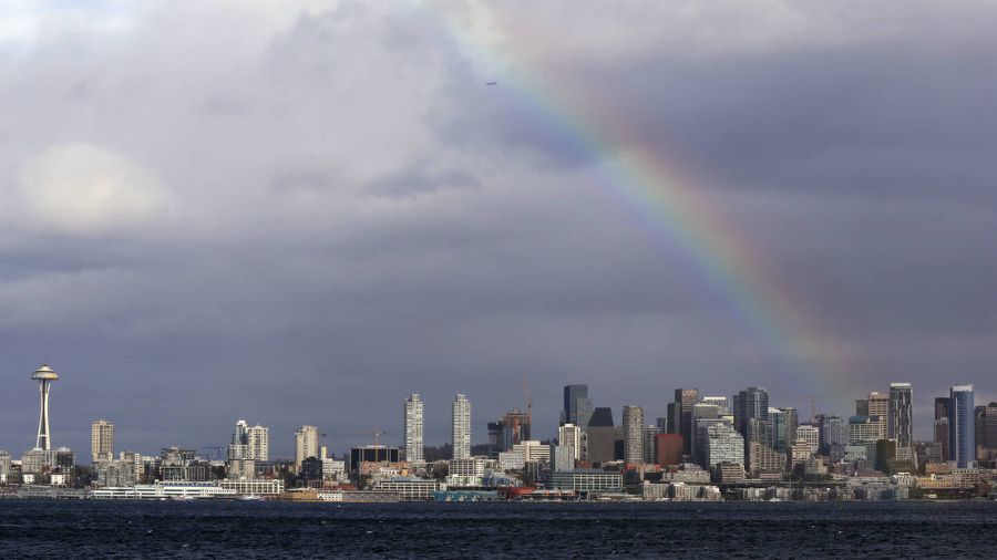
A rainbow briefly lights up over downtown Seattle, in Western Washington, and the Space Needle between rain and windstorms Monday, Nov. 13, 2017, in Seattle. (Elaine Thompson, AP)
(Elaine Thompson, AP)

The Washington State Department of Ecology (DOE) declared a drought emergency for much of the state earlier this week. History shows below-average precipitation years, like this past winter, often, but not always, result in more wildfires and wildfire smoke.
By state law, Washington declares a drought emergency when a lower-than-average precipitation and water supply condition threshold is reached. For a part of the state to be considered in drought is when that area is below or projected to be below 75% of normal and a water shortage is likely to create undue water supply conditions for a wide variety of water users.
More coverage: Washington remains in the grips of drought, will stay there
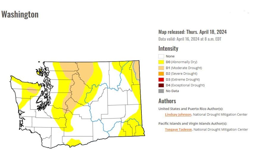
A map of April 2024 drought monitoring in Washington. (Image courtesy of Ted Buehner, MyNorthwest)
How winter’s snowpack played into drought conditions
This past winter season’s mountain snowpack played a critical role in the drought emergency declaration. As of April 15, the Northwest Avalanche Center reported Hurricane Ridge in the Olympic Mountains had a depth of only 51 inches of snow or only 48% of normal. Locations in the North Cascades such as Mt. Baker were only at 56% of normal snowpack.
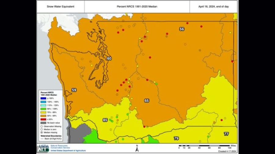
April 16, 2024, snowpack. (Image courtesy of Ted Buehner, MyNorthwest)
The central Cascades were just a bit better, ranging from 50 to 75% of normal, while the south Cascades were in the best shape, varying from 73 to 87% of average.
The amount of water in the mountain snowpack was also not very good, ranging from only around 60% of normal in the northern part of the state to at best 84% in the south Cascades. The mountain snowpack usually peaks around April 1 and the snowpack is now beginning to run off into streams as warmer spring weather arrives.
Unless a cool wet remainder of spring unfolds, this situation means the mountain snowpack will be depleted earlier than normal, leaving less water supply for agriculture, power generation, fish and water consumption later this year. Hence, the DOE has declared a drought emergency so state resources can be released to assist the wide variety of water users.
What makes a drought
Washington bases its drought determinations on a drought definition found in state law. The definition is water supply-focused and includes both a hydrometeorological and impact threshold. An area is considered to be in drought when the water supply for that geographic area, or for a significant portion of that geographic area, is below or projected to be below 75% of normal and the water shortage is likely to create undue hardships for water users or the environment. Normal water supply is defined as the median amount of water available for the most recent official climate period (currently 1991–2020).
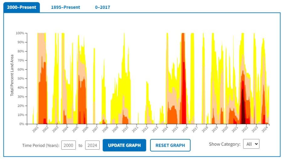
A map of 21st century drought conditions. (Image courtesy of Ted Buehner, MyNorthwest)
Snowpack is critical to Washington’s water supply. Around three-quarters of the runoff from the Cascades originates as snowpack. (How much runoff originates as snow?)
This snowpack acts as a natural reservoir, and a weak snowpack, or a shift in the timing of snowmelt, can impact water supply in the spring and summer. Some lower-elevation basins are more rain-dominant and spring precipitation is important for filling up soil moisture before the summer dry period develops.
Annual precipitation varies drastically across the state, with coastal Washington receiving over 80 inches of precipitation, on average, and parts of the Lower Columbia Basin east of the Cascade Mountains receiving less than 10 inches.
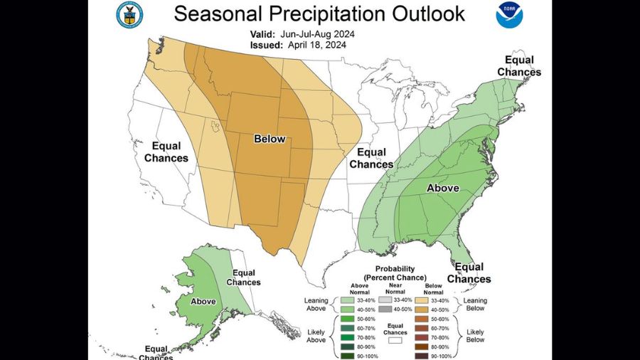
The Seasonal Precipitation Outlook for June-August of 2024. (Image courtesy of Ted Buehner)
When making drought determinations, the state Water Supply Availability Committee considers forecasted conditions in addition to existing conditions. Streamflow forecasts from both the National Weather Service and the Natural Resources Conservation Service are primary factors, but other hydrometeorological variables are considered as well.
Imagine water in a stream flowing around a large rock. The water wraps around the rock and meets on the other side. On a grand scale, that’s what happens with westerly airflow off the Pacific as the airflow wraps around the Olympic Mountains and collides or ‘converges’ just east of the Olympics.
South Snohomish County is ground zero for the convergence zone. The air flows around the Olympics through the Strait of Juan de Fuca and the Chehalis gap, collides, rises and produces clouds and then rain. If it is cold enough, it can even snow. Thunderstorms can also develop. With frequent stronger flow through the Strait of Juan de Fuca, the convergence zone tends to drift south into King County over time, similar to what occurred early this week.
The Puget Sound Convergence Zone can occur anytime during the year, but springtime is when it happens most often. Ironically, areas to the north and south of the convergence zone tend to have large breaks in the cloud cover with periods of sunshine, such as north in the San Juans and Skagit County, and south in areas such as Renton into Tacoma.
April showers bring more rainbows
Spring also marks the peak of the North Sound rainbow season. Rainbows can occur any time of year but the combination of spring showers and a higher sun angle than winter creates a greater number of rainbows during this season.
Rainbows are created by sunlight and rainfall from clouds or water droplets hanging in the air after rainfall. Sunlight enters a water droplet, slowing and bending the light as it goes from air to denser water. The light reflects off the inside of each rain droplet, breaking it into its different colors. When the light then exits the rain droplets, it creates a rainbow.
Buehner: Puget Sound Convergence Zone brings sunshine, showers, rainbows
Sunlight is composed of a spectrum of colors and many wavelengths of light. Violet is the shortest wavelength and bends the most. Red has the longest wavelength and bends the least. When you see a rainbow, the light reflecting back to you, with the sun at your back, will show all the colors between violet and red with violet on the bottom and red on the top.
Spring is here and it’s rainbow season — among the most beautiful displays of nature. If you see one, take pictures and share them on the KIRO FM Facebook so everyone can enjoy them.
Ted Buehner is the KIRO Newsradio meteorologist. You can read more of Ted’s stories here and follow him on X, formerly known as Twitter.