‘We got a real gut punch from it:’ Scientist recalls deadly Mount St. Helens eruption
May 18, 2024, 8:44 AM | Updated: 9:55 am
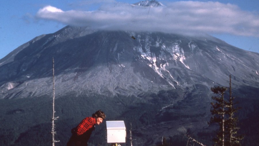
On May 17, 1980, Carolyn Driedger examines a piece of measuring equipment at Coldwater2, the spot near Timberline parking lot where the USGS was monitoring the expanding bulge on Mount St. Helens (visible in the background); the mountain erupted the next morning, killing 57 people. (Photo provided to KIRO Newsradio by Mindy Brugman courtesy of Carolyn Driedger)
(Photo provided to KIRO Newsradio by Mindy Brugman courtesy of Carolyn Driedger)
This weekend will mark the 44th anniversary of the May 18, 1980 eruption of Mount St. Helens, a profound event for anyone who remembers it or who has read the stories, and seen the photos and video.
For this year’s observance, KIRO Newsradio caught up with a retired longtime employee of the Cascades Volcano Observatory who shared her memories of the event, the impact it had on her life and career, as well as some thoughts about being prepared for future eruptions of Washington and Oregon’s iconic peaks.
Carolyn Driedger is Scientist Emerita of the United States Geological Survey’s (USGS) Cascades Volcano Observatory in Vancouver, Washington. She retired in 2023 after serving as the outreach coordinator from the time that position was created in the 1990s.
Driedger grew up in Pennsylvania and went to work as a young scientist for the USGS studying glaciers in 1978. By March 1980 when a minor eruption signaled that Mount St. Helens was wide awake after more than a century of slumber, it was clear that most USGS staff in this area were going to be involved with the volcano in one way or another.
A friend and colleague named Mindy Brugman was studying Shoestring Glacier, which was located on the east side of Mount St. Helens. Brugman invited Driedger to make a trip to Mount St. Helens one Saturday afternoon in the spring of 1980. They left Tacoma in a government car around noon and drove toward the mountain. They successfully got past the checkpoints keeping most people out of the area immediately around the volcano, and then headed to a place north of the peak called Timberline parking lot.
More from Feliks Banel: The game-changing Boeing 707 jet debuted 70 years ago
Timberline was near there where the USGS had set up equipment to measure the rapidly growing bulge on the north side of Mount St. Helens, where pressure from within the earth was literally changing the contours of the landscape by the hour.
Planning a trip north
The date of Driedger and Brugman’s field trip? It was Saturday, May 17, 1980.
“It was pretty intimidating to be at the Timberline parking lot the afternoon on May 17,” Driedger told KIRO Newsradio, “and (be) thinking, ‘Gosh, if that slid, it would probably come down right on top of us. Okay, that’s interesting, in a very intellectual sense.'”
Driedger says that though she and Brugman were actually having those thoughts there in the Timberline parking lot, it wasn’t enough to make the two scientists turn around and immediately leave.
“There is strength in numbers, somehow,” Driedger explained. “And if you see other people there – you know, you see other people taking risks – then you are more apt to take (risks) yourself.”
The USGS scientist on duty near Timberline keeping watch over the growth of the bulge was Harry Glicken. He had been there for a few weeks, and was about to be relieved by another USGS scientist named David Johnston.
For those who know their Mount St. Helens history or if people remember 44 years ago, you already know the name David Johnston. He was a young scientist – just 30 years old – and a beloved colleague to many. Johnston became the human face and voice of the USGS in those seven weeks between the first visible volcanic activity in late March 1980 and the massive eruption of May 18.
Driedger says that she and Brugman had planned to camp near the mountain that night, and then do field work at Shoestring Glacier the next day.
Johnston didn’t think that was a good idea.
“David was very clear that he thought that we were all at risk,” Driedger said. “And he said, ‘Let’s have as few people here as possible.’ And he said that several times over a couple of hours. He was he was very congenial, calm, and yet pretty serious when he made those statements.”
“And so reluctantly in early evening,” Driedger continued, “Mindy and Harry Glicken and I put our things back in our cars and we proceeded down the mountain, pretty crestfallen. It was a beautiful evening, you know, one of those where you want to just camp next to the volcano and just check on it at night and check on the stars shining on it.”
Northwest history: Visiting Captain Vancouver’s grave in a tiny village near London
‘It was black’
The next morning, Driedger and Brugman planned to return to the mountain and to try and get a helicopter to take them over to Shoestring Glacier. First order of business was a 7 a.m. meeting at the USGS office in Vancouver, and then they headed toward the mountain via Interstate 5 (I-5).
As they drove north, the sky up ahead began to look very odd.
“Instead of it being a little spurt of ash and steam in the sky, it was black,” Driedger recalled. “And it curiously was on the north side of the summit, and it was a kind of like a flat black line that extended to the north, which was really odd.”
Still, they kept driving.
“I think Mindy was the first one who mouthed that, ‘Oh, my gosh, maybe this is what’s actually happening, and what David had told us maybe is actually happening right now,'” Driedger said.
What Johnston had said was if a slide occurred on the north side of the mountain – if the bulge gave way – then the ensuing eruption could reach the observation post (known as Coldwater2) where Driedger and Brugman had been speaking with him just hours before.
‘Vancouver. Vancouver. This is it!’
Of course, Johnston was absolutely right. They didn’t know right away what had happened to their colleague, but Driedger confirms that Johnston did make that haunting final radio transmission back the USGS office as the eruption was getting underway: “Vancouver. Vancouver. This is it!”
“Oh, that is true, he was on the radio,” Driedger said. “And that would be David, and I know he was very excited that there would be activity here at Mount St. Helens.”
Driedger also says Johnston was not naturally someone you would think of as a spokesperson, but that in those weeks before the eruption, he rose to the occasion because he believed the information he was sharing was critically important for people to know and understand.
“There’s a lesson here in that,” Driedger said, “because although he was very shy, when he saw that people could be in trouble, that people could be hurt, he found the words, and he spoke out, and he spoke his piece.”
David Johnston’s body was never found, and it’s presumed that he died in the eruption there at what’s now called, in his memory, Johnston Ridge. The Forest Service observatory/visitor center at Johnston Ridge is usually a must-see, but the facility is currently closed and inaccessible due to a landslide that has been blocking Highway 504 for months.
‘What we thought was stable was not at all’
Meanwhile, on that drive north 44 years ago, Driedger and Brugman pulled off the freeway at Woodland. They called the office in Vancouver, and then turned around to head back there to help out as the USGS kicked into full response mode. Driedger was there for the rest of the day and into the night, taking calls from people asking questions, but also collecting reports from people describing what they saw.
A few days later, Driedger got a firsthand look at the devastation, flying over the eruption area Tuesday evening in a fixed-wing aircraft and peering down through night-vision goggles.
“It was extraordinary to see the amount of change, you could not believe the amount of change that happened in just a few minutes time,” Driedger said. “And I think that was the biggest ‘wow,’ to me, was that so much change could happen so quickly at this volcano, and that we really lived on an impermanent earth.”
“What we thought was stable was not at all,” Driedger said. “And I think that really shook everybody.”
“Mount St. Helens really brought home disaster in unexpected way,” Driedger continued. “Everybody wanted an eruption that would make the tourists happy. You remember that before May 18 there were people hawking T-shirts? It felt a little bit like (we were all) tempting the volcano. But we got a real gut punch from it instead.”
The devastation of the landscape and the loss of life took time to process, and Carolyn Driedger eventually had to get away.
“I never saw Mount St. Helens as a place to go play again for probably a couple of decades,” Driedger said. “And when my time was finished at Mount St. Helens, I did some studies looking at different aspects of glaciers on volcanoes and volcanic ash and snow melt, I went back to glaciology and went to up to Alaska, where I worked for four years.”
Reporting live from Washington’s past: History only deepens community love for Kirkland’s ‘mystery cottage’
Driedger once ‘couldn’t imagine going back,’ but she did
“It was a real relief to be away from volcanoes,” Driedger said. “And I just couldn’t imagine going back.”
But she did go back. First, Driedger worked on a project at Mount Rainier concerning glacial generated debris flows, which led to an invitation to join the staff at the USGS Cascades Volcano Observatory. In 1995, she was tapped by the USGS for a new position to lead outreach efforts for Cascades Volcano Observatory. Her job was to work with communities on updating hazard assessments, to create curriculum for educators, to provide up-to-date information for interpretive guides at the Mount St. Helens National Volcanic Monument, and to share information with the media. The goal was to use data and communications to save lives.
Carolyn says that ultimately, the biggest lesson from Mount St. Helens in 1980 was that there was more that scientists could do to help communities prepare for the next eruption – since Rainier, Baker and Glacier Peak and other Cascade volcanoes are right here in our backyard, and because it’s just a matter of time before one of them erupts again.
Holly F. Weiss-Racine is the current outreach coordinator at Cascades Volcano Observatory. She’s keenly aware of the Carolyn’s Driedger role in establishing the position nearly 30 years ago.
“I met Carolyn in her role almost 20 years ago during the 2004-2008 lava dome building eruption of Mount St. Helens when I was a Park Ranger at the Mount St. Helens National Volcanic Monument,” Weiss-Racine wrote in an email. Weiss-Racine describes Driedger’s legacy as “all she has done to keep our communities educated and connected to our beautiful, but dangerous, Cascade Volcanoes.”
The way Carolyn Driedger describes her work as outreach coordinator, and her continued role as a volunteer for Cascades Volcano Observatory, it’s a kind of healing from what she witnessed firsthand 44 years ago.
“I think that was very cathartic for me to be able to do something positive,” Driedger explained. “Yes, I had seen the situation where 57 people died. But here, I was able to do something about it, and so I spent the rest of my career doing that.”
Editors’ note: This story originally was published on Wednesday, May 15, 2024. It has been updated and republished since then.
You can hear Feliks Banel every Wednesday and Friday morning on Seattle’s Morning News with Dave Ross and Colleen O’Brien. Read more from Feliks here and subscribe to The Resident Historian Podcast here. If you have a story idea or a question about Northwest history, please email Feliks. You can also follow Feliks on X, formerly known as Twitter.